Thursday, March 28, 2013

Secrets of the Dead: The Lost Ships of Rome


Secrets of the Dead: The Lost Ships of Rome was aired on PBS in November 2010. Now it is available on a DVD. It is an interesting and informative documentary about ancient Roman history, but there are some loose ends and some unanswered questions, as I will explain below.

Here is some information about the production: 

** Narrated (in English) by Liev Schreiber
** Written and produced by Robert Hartel
** Underwater Photography: Roberto Rinaldi
** Total Running Time: 52 minutes

In 2009 five wrecks of ancient Roman ships were discovered on the bottom of the sea near Ventotene, a remote Italian island ca. 43 miles (ca. 69 km) west of Naples. The film follows a team of archaeologists and divers who attempt to recover some items from these wrecks. The ships have rotted away, but the cargo is still quite well-preserved. Reaching these sites is not easy, because the depth of the water is 300 feet (100 m) or more.

Timmy Gambin is the leader of the archaeological team, while Roberto Rinaldi is the leader of the diving team.

From time to time the main story is interrupted by several short digressions about the ancient history of the island, which cover the following cases:

* The imperial palace, which the Roman emperor Augustus built for himself

* The Roman system of water management, which includes two underground cisterns

* The Roman harbour, which was excavated from the rock of the island

* Roman dishes based on the ancient cookbook by Apicius, including the famous fish-sauce known as “garum”

* The history of Julia, Augustus’ only daughter, who was banished to this island for five years (but the Roman name of the place – Pandateria – is never mentioned)

Most of the information about Julia and her tragic fate is provided by an on-screen witness: Annelise Freisenbruch, a classical scholar, who is the author of The First Ladies of Rome: The Women behind the Caesars (2010, 2011).

During the interview there is a glimpse of another book on the table next to her: Julia Augusti: The Emperor’s Daughter by Elaine Fantham (2006).

These digressions are not directly relevant for the diving project, but they are interesting and welcome, because they give the film a wider scope.

3D computer-generated images are used to show us what the imperial palace looked like; how the Roman system of water management worked; how the Roman harbour basin was excavated; and how the ancient containers (known as amphorae) were stacked when they were being transported in a Roman cargo ship.

Here is a brief report of the diving project:

DAY 1
The divers reach wreck # 1 and recover an amphora, which is brought to the surface. It is from Italy, it was used to transport wine, and it is from the end of the first century BC, i.e. the time when Augustus was emperor and when his daughter Julia was banished to Pandateria.

DAY 2
The divers reach wreck # 2 and recover a Roman bowl used for grinding food. It is brought to the surface.

DAY 3
The divers attempt to reach wreck # 3, but they do not succeed

DAY 4
Strong winds prevent the team from going out to the diving sites. Instead Gambin and Rinaldi perform an underwater inspection of the Roman harbour.

DAY 5
The divers attempt to reach wreck # 4. They see some mysterious ancient cylinders, but they are unable to recover one of them.

This film is well-done, and the material is well-organised: scenes on the water alternate with scenes on land. Words and pictures complement each other very well. The underwater footage of the ancient Roman items is surprisingly clear and sharp. But when we get to the end of the film, when the team is celebrating with wine and homemade garum, there are some loose ends and some unanswered questions:

After five days what do they have? One amphora and one bowl. Not much for five days. In the beginning of the film we are told that the team has only five days. But we are never told why the project must be completed in such a short time.

Five days to recover items from five different wrecks in deep water sounds like a very tight schedule. As it turns out, the schedule is too tight. Why not allow for a day with bad luck? Why not allow for several days with bad weather? If these five wrecks are so important, why not make sure there is enough time to recover at least one item from each of the five wrecks?

Wreck # 1 holds perhaps 100 amphorae. Why take only one? Why not take 2, 4 or 6 to have more evidence? The same question can be asked about the bowl recovered from wreck # 2.

The amphora is lifted with a single rope tied around its neck, and the members of the team worry that the ancient item is going to break. Why not use a net, which is a much safer way? The bowl from wreck # 2 is lifted in a net. Perhaps they did not think of using this method until the second day?

What happened to the amphora which was recovered? We are told it was taken to the local museum to be cleaned up and to be inspected. What did it look when it was cleaned up? What did the archaeologists find out when it was inspected? The same questions can be asked about the bowl recovered from wreck # 2.

I like this film. It is interesting and informative. It covers a lot of ground in less than an hour. I want to recommend it. But I cannot ignore the loose ends and the unanswered questions, and therefore I cannot give it more than four stars.

* * *
 
Secrets of the Dead:
The Lost Ships of Rome,
PBS, 2010, 52 minutes
 
* * *


Life and Letters on the Roman Frontier


Life and Letters
on the Roman Frontier:
Vindolanda and its People


Front Cover


Life and Letters on the Roman Frontier with the subtitle Vindolanda and its People by Alan K. Bowman was published in 1994. A second edition appeared in 1998. A third edition (published in 2003) was reprinted in 2006 and 2008.

Bowman (born 1944) is professor emeritus of ancient history at Oxford University. This book is an excellent introduction to the amazing evidence from Vindolanda, a Roman fort in the north of England, not far from Hadrian's Wall. Since 1973 archaeologists have discovered hundreds of ancient documents written with ink on thin pieces of wood, known as the Vindolanda writing-tablets.

Many are short, but a few are rather long. Many are fragments, but some are (almost) intact. Most of the documents which can be dated were written around the year AD 100. Taken together they provide a unique insight into the lives of the men and women who lived in this place almost two thousand years ago.

The book is divided into two parts. In part one the tablets are discussed and interpreted; they are placed in context. In part two a selection of 50 documents are printed in Latin and in English.

The book concludes with a bibliography, and an index. Illustrations include three maps of the Vindolanda area and photos of some of the tablets, which are discussed in part one and printed in part two: you can compare the original with the printed version.

[Some of the tablets are available online at the Centre for the Study of Ancient Documents. While this website is interesting, it is no substitute for this book: CSAD.]

Part one is divided into seven chapters. Here are the headings:

1. Introduction
2. The Writing-Tablets
3. Strategies of Occupation
4. The Roman Army
5. Officers, Men, and Women
6. Social and Economic Life on the Frontier
7. Letters and Literacy


At the end of each chapter there are notes with references to modern works and ancient sources, including the tablets. As you can see from the list, each chapter covers one aspect of the general topic. The text is well-written, and the material is well-organised.

Part one concludes with a discussion of literacy in the ancient world. Bowman has covered this issue elsewhere: he is the author of a chapter in Literacy in the Roman World (1991) and the co-editor of Literacy and Power in the Ancient World (1994, 1996).

When discussing this issue, we can try to quantify and measure, as William Harris does in Ancient Literacy (hardcover 1989, paperback 1991). But it is difficult and, as Bowman points out, it is important to remember that there are degrees of literacy (page 79).

The Roman civilization was a literate one, and the evidence from Vindolanda allows us to study "the character of that literacy at the periphery of the Roman world and its role in the organization of that provincial region and society" (page 80).

The writing-tablets from Vindolanda are often compared with the papyri from Egypt. When we consider the papyri from Egypt, we may get the impression that literacy was relatively high for the ancient world, and we have to ask: is the case of Egypt unique or typical? Perhaps literacy in Egypt was relatively high because of a literate tradition in this part of the world. The evidence from Vindolanda, the other end of the empire, is surprisingly similar to the evidence from Egypt, which allows us to argue that literacy was relatively high in every part of the Roman Empire.

Part two is divided into two sections, "Technical Terminology" and "The Texts." For reasons of space only a few examples can be mentioned here:

(1) Claudia Severa sent a birthday invitation to Sulpicia Lepidina (doc. # 31). The official invitation was written by a professional scribe, but Claudia Severa added a personal closing in her own hand:
sperabo te soror
vale soror anima
mea ita valeam
carissima et have
"I shall expect you, sister. Farewell, sister, my dearest soul, as I hope to prosper, and hail."

This letter is unique, because it is written by a woman to another woman. Claudia Severa is the wife of an officer. Sulpicia Lepidina is the wife of another officer. It is hardly surprising that they are literate.

(2) Hunting was a popular pastime among officers. This topic is the subject of a letter from Flavius Cerialis to Brocchus (doc. 24):
Flavius Cerialis Broccho
suo salutem
si me amas frater rogo
mittas mihi plagas
 
"Flavius Cerialis sends his greetings to his Brocchus. If you love me, brother, I ask that you send me some hunting-nets."

Flavius Cerialis and Brocchus are both officers. It is hardly surprising that they are literate.

(3) Soldiers would sometimes make a request for leave. Two examples are given in doc. 5. We do not know the name of the first soldier, nor do we know the place he wants to visit, Ulucium:
rogo
dignum me habeas
cui des commeatum
Ulucio
"I ask ... that you consider me a worthy person to whom to grant leave at Ulucium."

The second soldier, Messicus, wants to visit Coria, which is the Latin name for Corbridge, another fort near Hadrian's Wall: 
habeas cui
des commeatum
Coris Messicus
rogo domine
 
"I, Messicus..., ask, my lord, that you consider me a worthy person to whom to grant leave at Coria."

Both letters are probably written by ordinary soldiers. They follow the same pattern, but we are not dealing with a form where the soldier only needs to fill in his name. Each soldier writes the whole text, which shows some degree of literacy among the rank and file.

Life and Letters on the Roman Frontier is a great book. If you are interested in the history of ancient Rome - what we know and how we know it - I am sure you will enjoy this book.


* * *
 
Alan K. Bowman,
Life and Letters on the Roman Frontier:
Vindolanda and its People,
British Museum Press
First edition 1994, second edition 1998, third edition 2003, 179 pages
 
* * *


Literacy in the Roman World


Literacy in the Roman World – Special Supplement # 3 from the Journal of Roman Archaeology – was published in 1991 in response to a famous book by William Harris: Ancient Literacy (hardcover 1989, paperback 1991).

Several scholars were invited by JRA to comment on this book. Eight scholars responded in good time, and their contributions were published together as Special Supplement # 3.

In a short preface, John Humphrey (editor of JRA) explains:

“The contributors were given complete latitude regarding the aspects of the book and of the topic on which they wished to focus, except only that the emphasis was to be Roman rather than Greek or Hellenistic.

All eight scholars accept Harris’ basic conclusion that the level of literacy in the classical world (ancient Greece and ancient Rome) was never high, but this does not mean that there is nothing to complain about. In what follows I will give a brief presentation of the eight scholars and their contributions:

** Tim Cornell (born 1946) is professor emeritus of ancient history at the University of Manchester and the author of several books, including The Beginnings of Rome (1995). His contribution has the title: “The tyranny of the evidence: a discussion of the possible uses of literacy in Etruria and Latium in the archaic age.”

Harris claims archaic Italy and the Early Roman Republic had almost no writing, and most of it was used for religious affairs (e.g. funerals). It was not used for business or administration. Cornell presents a broad selection of evidence to show that this view is misleading and too pessimistic. In my opinion he is quite convincing.

** Mary Beard (born 1955) is professor of Classics at Cambridge University and the author of several books, including Pompeii: The Life of a Roman Town (2008). Her contribution has the title: “Ancient literacy and the function of the written word in Roman religion.”

Harris claims writing was essential to the Christian religion, but only marginal in the pagan Roman religion. Beard presents a broad selection of evidence to show that this view is not always correct. In my opinion she is quite convincing.

** Nicholas Horsfall is honorary professor of classics and ancient history at Durham University and the author of several books, including four commentaries on Virgil’s Aeneid (book 2, 3, 7 & 11, published 2000-2008). His contribution has the title: “Statistics or states of mind?”

Harris claims that ordinary workers were unable to read and write. Horsfall presents a broad selection of evidence to show that this view is too pessimistic. In my opinion he is quite convincing.

** James L. Franklin Jr. is professor of classical studies at Indiana University and the author of several books, including Pompeis Difficile Est (1999, 2001). His contribution has the title: “Literacy and the parietal inscriptions of Pompeii.”

Harris claims literacy in provincial towns was relatively low. Franklin presents a broad selection of the amazing evidence from Pompeii to show that this view is not always correct. In my opinion he is quite convincing.

  
Fig. 1, page 83. CIL IV.2487.
This is a famous Latin epigram. The inscription reads:
"Admiror te paries non cecidisse (ruinis) //
qui tot scriptorum taedia sustineas."
Here is an English translation of the Latin text:
"I admire you, wall, because you have not collapsed into ruins,
even though you are holding up the silly messages of so many poets."


 Fig. 2, page 85. CIL IV.3884.
This is an invitation to watch the gladiator games in the amphitheatre. This message about the games (edictum munerum) was written with beautiful letters by a professional writer Aemilius Celer, who left his name two times: in the middle of the letter C and on the right (next to the main text).


Fig. 3 page 90. CIL IV.8066.
Drawings of two gladiators on a wall in a house. On the left Oceanus, a former slave. The letter L after his name stands for "libertus." He won 13 times (XIII). On the right Aracintus, also a former slave, who won four times (IIII).


 Fig. 4, page 94. CIL IV.4755.
The architect Cresces (Crescens) left his name and title on the wall of a house, working them into the shape of a boat by extending some of the letters downward to form oars and tracing the lower bend of the final S back under the whole inscription to suggest a keel. The upward extension of the first T of the word "architectus" to form a mast completed the effect.


** Mireille Corbier is director of research at the Paris-based CNRS and the author of several books, including Donner a voir, Donner a lire: Memoire et communication dans la Rome ancienne (2006). Her contribution (published in French) has the title: “L’écriture en quête de lecteurs.”

Harris insists we must have evidence for everything. If there is no surviving evidence for a school in a certain town, it becomes an argument to say there was no school in this town. Corbier points out that this method can be dangerous: what if there was a school? What if the evidence had disappeared? A basic archaeological dictum says: absence of evidence is not evidence of absence. The method used by Harris may have led him to conclusions which are too pessimistic.

[This chapter includes a reference to the monument erected for Titus Flavius Secundus at Cillium (in present-day Tunisia). For more information about this monument, please turn to Jon Davies, Death, Burial and Rebirth in the Religions of Antiquity (1999) pp. 150-152 (the monument) & 221-224 (the Latin inscription).]

** Alan K. Bowman (born 1944) is professor emeritus of ancient history at Oxford University and the author of several books, including Life and Letters on the Roman Frontier (first edition 1994, second edition 1998, third edition 2003). His contribution has the title: “Literacy in the Roman Empire: mass and mode.”

Harris claims literacy among ordinary soldiers was limited. Bowman presents a broad selection of the amazing evidence from Vindolanda - the Roman fort near Hadrian’s Wall - to show that this view is not always correct. In my opinion he is quite convincing.

** Keith Hopkins (1934-2004) was professor of ancient history at Cambridge University and the author of several books, including A world Full of Gods (1999). His contribution has the title: “Conquest by book.”

Harris claims the average level of literacy was low in the ancient world. Hopkins presents a broad selection of evidence from Roman Egypt to show that this minimalist view could be too pessimistic. In my opinion he is quite convincing.

** Ann Ellis Hanson is a classical scholar at Yale University and the author of several articles (but not a single book). Her contribution has the title: “Ancient illiteracy.”

This contribution presents an interesting selection of evidence from Roman Egypt, but the purpose is not to challenge Harris’ view. Of the eight scholars, who responded to the invitation from JRA, Hanson is the only one who does not criticize or question any part or aspect of Harris’ book.


Fig. 2, page 198.
This ancient papyrus from Egypt (P. Geneva. inv. 213) is a declaration of death. According to
Ann Hanson, the purpose of the document is "to relieve relatives of the deceased from further
attemps to collect the tax and from harassment by officials" (page 197).

Literacy in the Roman World is an interesting collection about an important topic. I like it, but I can only give it four stars. If I like it so much, why give it only four stars? Because there is no bibliography, no index, and very few illustrations.

PS # 1. Some Romano-British curses (mentioned by Mary Beard) and some Vindolanda Tablets (mentioned by Alan K. Bowman) are now available online. See the website of CSAD: Centre for the Study of Ancient Documents.

PS # 2. In 2002 JRA published another volume about this topic: Becoming Roman, Writing Latin? Literacy and Epigraphy in the Roman West, Special Supplement # 48, edited by Alison E. Cooley.

PS. # 3. For more information about this topic see Literacy and Power in the Ancient World edited by Alan K. Bowman and Greg Woolf (Cambridge University Press, hardcover 1994, paperback 1996).

* * *

Literacy in the Roman World,
The Journal of Roman Archaeology,
Special Supplement # 3, 1991, 198 pages

* * *


Wednesday, March 27, 2013

Petra: The Rose-Red City


This pocket-size book about the ancient city of Petra is written by two professional scholars: Jean-Marie Dentzer and Christian Augé.

Jean-Marie Dentzer is Director of the Institut Français d’Archéologie du Proche-Orient and a professor at the Université de Paris I. He is past leader of an archaeological team from the Centre National de la Recherche Scientifique (CNRS), working in southern Syria and Jordan, and author of numerous articles.

Christian Augé is Director of Research at the Centre National de la Recherche Scientifique (CNRS). A specialist in ancient coins and the classical iconography of the Near East, he succeeded Jean-Marie Dentzer as leader of an archaeological team in southern Syria and the Petra region of Jordan.

The text is divided into four chapters. Here are the chapter headings:

# 1 – Petra Revealed
# 2 – The Kingdom of the Nabataeans
# 3 – From Refuge to Caravan Capital
# 4 – Anatomy of a City

At the end of the book we find six short sections: some documents, a list of Nabataean kings, a chronological table, a bibliography, a list of illustrations, and an index.

Throughout the book there are many illustrations, mostly photos but also some drawings. Almost all illustrations are in colour. The quality is high, but the size is rather small. This is no surprise, since the book measures only 12.5 x 17.5 cm.

Please note: this is not a guidebook. It does not describe the monuments of Petra one by one, and it does not give you any suggestions about how to arrange a walk through the ancient town. If you need a guidebook, you must turn to Lonely Planet, the Rough Guide, or something like that.

This book by Jean-Marie Dentzer and Christian Augé gives you background information about Petra and the Nabataean civilization. The text is well written and well organised. Clearly, the authors know their topic very well. All the major issues are discussed, including the question of water management, which is covered on pages 59-62.

For more information about this question, please turn to Charles Ortloff, Water Engineering in the Ancient World (Oxford University Press, 2009).

Please note: the French original was published in 1999. The English translation was published in the following year. It was reprinted (apparently without any changes) in 2006. This means that it does not include the results of recent archaeological discoveries in the centre of the city.

The map of Petra on pp. 116-117 shows the colonnaded street. At the eastern end the nymphaeum is marked, at the western end the triple arch and Qasr Al-Bint are marked. But several monuments are not marked here: the Great Temple, the Upper Market, the Central Market, and the Lower Market (south of the street), the Royal Palace and the Petra Church (north of the street).

For more information about the results of recent archaeological discoveries, please turn to Francesca Ossorio, Petra: Splendors of the Nabataean Civilization (White Star Publishers, 2009), pp. 118-153.

The two French scholars have written an interesting account about the ancient city in the Jordanian desert. It is not a guidebook, but I cannot complain about this, because it does not pretend to be a guidebook. It is not quite up to date, but I cannot complain about this either, because it was reasonably up to date when it was first published, around the year 2000.

If you are looking for quick and reliable background information about Petra and the Nabataean civilization, this book is highly recommended.

* * * 
 
Jean-Marie Dentzer & Christian Augé,
Petra: The Rose-Red City,
Thames & Hudson: New Horizons, 2000, 2006, 128 pages
 
* * *
 
For more information about Jordan see my blogs:


* * *


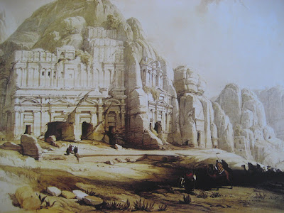
David Roberts in Petra (1839)


 (# 10) The eastern end of the valley - the royal tombs - the Palace Tomb.
 
David Roberts (1796-1864) was a Scottish artist. In 1838 he was in Egypt. In the following year he travelled to Syria and Jordan. During his stay in and around Petra, he made a series of 14 large and very detailed drawings in colour. This collection has recently been republished in full-scale and in colour.

As you can guess, the collection is on sale in the shops in the ancient city and in some of the shops in Wadi Musa – the modern town next to Petra.

Here is a brief overview of the motives. The 14 sheets are not numbered, but I have decided to divide them into four groups and to number them here, because this will send you on a virtual tour through the ancient city from the beginning of the Siq (in the east) to the Monastery (in the northwest):

PART A

# 1: Encampment of Bani Said
# 2: Arabs of the tribe of Benisaid
# 3: Approach to Petra (Bedouins in the shade of a huge rock)

PART B

# 4: The arch at the beginning of the Siq (in the east)
# 5: The Treasury (al-Khasneh)
# 6: Lower view of the Treasury (al-Khasneh)
# 7: The Theatre

PART C

# 8: The eastern end of the valley – The Royal Tombs – The Tomb of the Urn
# 9:  The Tomb of the Urn
# 10: The eastern end of the valley – The Royal Tombs – The Palace Tomb
# 11: Sight to the south
# 12: The Acropolis

PART D

# 13: Ruins of the Triumphal Arch (in the city centre)
# 14: The Monastery (Ad-Deir) (in the northwest)

In every modern book about Petra there is at least one drawing by Roberts among the illustrations, sometimes even three, four or five drawings. See for instance Francesca Ossorio, Petra: Splendors of the Nabataean Civilization (White Star Publishers, 2009). When they are placed in a book, you can study them and enjoy them, but you cannot take them out. They belong in the book.

The new collection is not a book. The 14 sheets are not bound together. There are 14 loose sheets. Each sheet measures 24 x 33 cm. They come in a folder which is slightly larger (25 x 35 cm). You can pick out one and put it in a frame and hang it on the wall, if you like.

When Roberts visited Petra in 1839, the ancient city was beginning to be famous in Europe - that is why he decided to go there - but apart from the local Bedouins almost nobody had ever been there. Almost nobody knew anything about the place. That is why his drawings are so exceptional and valuable.

It is interesting to compare the drawings he made in 1839 with the current conditions in the 21st century. The decorations and reliefs on the monuments are often sharper and clearer in the old drawings than they are today. A common explanation for this is that erosion by rain, wind and desert sand has done a lot of damage since Roberts was there. This may be true, but it does not have to be.

When you make a drawing, you do not have to draw what you see. You can draw what you like. Maybe the decorations and the reliefs were already heavily eroded in 1839. Maybe Roberts drew what he wanted to see. Maybe he embellished the decorations and the reliefs, because he wanted them to look good. We can never know if he did this on some occasion or not.

In general his drawings are considered very accurate. When you compare details which he could see and draw with what we can see today, we have to say that his drawings are almost like a photo. He was a very careful and meticulous artist.

Picture # 4 shows the arch that once spanned the beginning of the Siq. Unfortunately, it is not there anymore. It collapsed in 1895. But you can still see the niches cut in the rock below the arch, and on the left wall you can see the beginning of the arch. Roberts shows one of the niches below the arch (the one on the right side) – but perhaps the niche is placed a bit too high in his picture?
 

(# 5) The facade of the Treasury - the third column from the left is broken.
 
 
(# 6) The Treasury - seen from the side - notice the broken column.
 
Pictures # 5 and 6 show the Treasury. One of the six columns on the front is broken in this picture. This detail is a fact. Today the broken column has been repaired. When you closely at the column, you can see the difference between the original cut by the Nabataeans and the modern reconstruction which was done in the 20th century.

 
(# 14) The Monastery also known as Ad-Deir (in the northwest).
 
Picture # 14 shows the Monastery. As far as I can see, it is a very accurate rendition of the ancient monument. There are no decorations or reliefs in the niches today. There are none in the drawing from 1839. Roberts could have made something up, to make it look more like the Treasury, or just to make it look better. But he did not. It seems he was a very faithful and very talented observer.

If you have never been to Petra, you may still enjoy these drawings from the 19th century. The motives are beautiful, and the composition of each scene is well done with one element in the foreground and another element in the background. When you look at these drawings, you may be able to understand why so many people visit this ancient city every year.

If you have been there, I am sure you will cherish and appreciate these drawings as a special souvenir from one of the most extraordinary and fascinating places in the world.

* * *
 
David Roberts in Petra (1839):
The Complete Collection
 
* * *
 
For more information about Petra see my blog:
 
 
* * *


Petra: Art and History


This beautiful book about Petra is published by the Italian publisher Bonechi which specialises in picture books about famous places around the world. Sometimes the focus is on a country. In this case the focus is on an ancient city in Jordan.

Books from Bonechi are available in many languages. I have used an English edition published in 2010.

The text – written by Dominique Tarrier – is clear and concise. In general it is accurate, but there are a few unfortunate mistakes, as I will explain below. The illustrations are numerous, and the quality of the illustrations is high.

In the beginning of the book there is a map of the ancient city where the major monuments are marked with numbers.

There are many pictures of the Treasury (pp. 17-25), which is no surprise. It is, after all, Petra’s most famous monument. They include two drawings by the Scottish artist David Roberts, who visited Petra in 1839. Other drawings by David Roberts appear on pp. 29, 36, 44, 54-55, & 74.

[The complete collection of his 14 drawings from Petra has recently been republished. See: David Roberts in Petra (1939).]

The modern photos in the book were taken several years ago. How do I know? For two reasons:

# 1: On page 21 we see visitors entering and exiting the building, and on pp. 24-25 we see visitors observing the interior of the monument. This is not allowed anymore. Today a fence is placed about four m from the columns. Today this monument can only be viewed from the outside.

# 2: On page 21 we can see that the area in front of the monument is untouched, so this picture was taken before excavations in this area were carried out. The excavations revealed an underground chamber, and they confirmed that the monument is a mausoleum for a Nabataean king. The entrance to the underground chamber is covered by a metal grill placed between the fence and the monument.

In general the text is accurate, but I have to mention a few things which bother me:

(1) The caption to the photo on page 12 reads as follows:

“The tunnel dug into the rock through which the waters of the Wadi Musa were deviated.”

The picture does show not the Nabataean tunnel. It shows the beginning of the Siq. The photographer is looking west. The tunnel is actually visible from the spot where the photographer stands. He or she only has to turn right and face north. If he does this, he can see the beginning of the tunnel.

(2) On page 15 we are told that “the gorge is never more than 2 m wide.” This false statement is refuted by the photo on the preceding page where we can see that the Siq sometimes widens to much more than 2 m. Sometimes the distance from wall to wall is 10 or even 20 m.

(3) The caption to the photo on page 28 reads as follows: “Petra’s theatre … was built on the right side of the main roadway.” This is not true. The theatre was cut into the rock on the left side of the road.

When we talk about the right or the left side of the road in Petra, we always assume that we are moving west from the Siq towards the Treasury and then further west towards the city centre and the new museum. The author makes this assumption in every other case, so why not do the same here?

The theatre was cut into the rock on the northern side of the road. If you are walking from the Treasury to the city centre, it is on your left side. Anyway, there is only one theatre in Petra, so you cannot miss it.

In the photos of the theatre we see visitors walking or sitting in the auditorium. Today you are not allowed to enter the theatre. Today this monument can only be viewed from the outside.

(4) Page 47 presents the tomb of Florentinus. The first name of the Roman governor is spelled Sextus, but the correct form of the name is Sextius.

(5) Page 52 presents the South Temple. This temple is located south of the Colonnaded Street, so the name makes sense, but the name commonly used for this monument is the Great Temple.

(6) Page 86 presents the tomb of Uneishu, who was a minister of Queen Shaquilat II, who was the wife of Malichus II (king 40-70) and the mother of Rabbel II (king 75/76-106). When her husband died and her son was still too young to rule, she served as his regent during the years 70-75/76.

The caption to the photo on the preceding page reads as follows:

“The Tomb of Uneishu can be seen in the centre of the photo.”

This is not true. The tomb of Uneishu cannot be seen in this photo. The large tomb in the centre of the photo, which does not have a modern name, is located ca. 100 m to the left – i.e. to the north – of Uneishu’s tomb.

To see some pictures of Uneishu’s tomb (the façade and the interior) you may turn to Francesca Ossorio, Petra: Splendors of the Nabataean Civilization (White Star Books, 2009) pp. 185, 206, 207, & 217.

The mistakes mentioned above are unfortunate, but in this case I do not want to be too harsh, because the illustrations are so great, not merely the modern photos, but also the 19th century drawings by the Scottish artist David Roberts. Therefore I think this book deserves a rating of five stars.

* * *
 
Petra: Art and History,
Bonechi, 2010, 96 pages
 
* * *
 
For more information about Jordan see my blog:


* * * 
 

Jordan: Art and History


This beautiful book about Jordan is published by the Italian publisher Bonechi which specialises in picture books about famous places around the world. Sometimes the focus is on a single city. In this case the focus is on a whole country.

Books from Bonechi are available in many languages. I have used an English edition published in 2010.

The general introduction (pp. 5-8) as well as the brief introduction to the section about Jerash (pp. 35-36) are written by Rami G. Khouri, who is the author of several books about ancient monuments in Jordan. The main text is written by Francesca Casule.

The text is clear and concise. In general it is accurate, but there are a few mistakes and unfortunate statements, as I will explain below. The illustrations are numerous, and the quality of the illustrations is high.

This book presents all the famous and important places in Jordan (except the ancient mountain fortress near Mukawir, also known as Machaerus). In some cases the presentation is rather brief, but I cannot complain about this. It has to be this way, since all major sites of the country are covered in one book. Here are some examples of the places presented in the book:

The capital Amman
One section covers the citadel with monuments from the Roman and the early Islamic period; a second section covers the lower city with the Roman theatre.

The Dead Sea and the surrounding area
One section covers Mount Nebo; a second covers Madaba; a third covers the Dead Sea itself.

The desert castles in the eastern part of the country
Qasr al-Hallabat; Qasr al-Azraq; Qasr al-Amra; and Qasr al-Kharana.

Gerasa – present-day Jerash – in the northern part of the country
There are 16 pages about this place, including a map of the ancient city.

Petra in the southern part of the country
There are 27 pages about this place, including a map of the ancient city.

Aqaba in the far south of the country
This town has an ancient fort, a museum, several modern hotels, and Jordan’s only port.

In general the text is accurate, but I have to mention a few things which bother me.

(1) On page 8 we are told that Jerash is “half an hour by car north of Amman.” The distance between the two places is 50 km. In theory, you can drive 50 km in half an hour, if you can maintain an average speed of 100 km/hour. In the real world, with traffic jams and traffic lights, this is impossible.

(2) On the same page we hear about “the formal proclamation of the Byzantine Empire in 324 AD…” There was no formal proclamation of the Byzantine Empire in AD 324 - or any time, for that matter. Emperor Constantine – known today as Constantine the Great – announced in 324 that he was going to move the capital of the Roman Empire to a new location further east. The location chosen was Byzantium, which had been founded by Greek colonizers ca. 600 BC. The new capital was dedicated six years later, in AD 330, and its name was changed to Constantinople.

In 395, following the death of Theodosius, the empire was divided into two. The western empire lasted until 476. The eastern empire lasted until 1453, when it was conquered by the Ottoman Turks, who changed the name of the capital city to Istanbul. Today the eastern Roman Empire is known as the Byzantine Empire, but this is a modern name.

(3) On page 35 we hear about one of the ancient monuments in Gerasa. It is called the “South Tetrakionia.” This term is quite unusual. The map on page 34 calls it the South Tetrapylon, which is the term commonly used.

(4) A bit further down, on the same page, we hear about another ancient monument: “the once domed North Tetrapyla.” Again, this term is quite unusual. The map on page 34 calls it the North Tetrapylon, which is the commonly used term.

Today the monument has a dome. It was rebuilt in 2000. It seems the text was written before that time, and it was not updated for this edition of the book which was published in 2010.

(5) On page 38 we are told that the hippodrome of Gerasa was “once capable of containing as many as 5,000 spectators.” The ancient hippodrome was relatively small, but it could hold around 15,000 spectators.

(6) On page 89 we hear about the Siq in Petra: “… the narrow passageway cut through by the waters of the Wadi Musa.” The Siq was not cut by water; it was created by a crack in the rock. This fact is actually mentioned on page 93: “The result of a natural calamity which split the mountain, the Siq is about 2 km long.” By the way, the Siq is 1.2 km long.

(7) The caption on page 102 refers to a picture on the following page: “Below, the triclinium.” The monument shown in the picture is known as the Garden Temple or the Garden Tomb.” It is # 37 on the map on page 88 where it is called the Garden Temple Complex.

(8) On page 124 we hear about Aqaba: “… the small archaeological museum housed inside the castle.” But the museum is located in a building next to the castle.

If I consider only the illustrations, this book deserves a rating of five stars, because the pictures are great. But I am afraid I have to consider the whole book, including the text. If I do this, I think a rating of four stars is correct.

* * *
 
Jordan: Art and History,
Bonechi, 2010, 128 pages
 
* * *
 
For more information about Jordan see my blogs:
 
 
* * *