Housesteads Roman Fort is one of several forts built along
(1) The
wall itself, running 80 Roman miles (118 km ) from coast to coast.
(2)
Milecastles with short and regular intervals. As the modern name says, the
distance from one milecastle to the next was one Roman mile, i.e. 1.5 km .
(3)
Watchtowers with short and regular intervals. Between two Milecastles there
were two towers. The distance between the towers was around 500
meters .
(4) Fifteen
forts along the wall.
(5)
Additional forts in the area, south of the wall four, north of the wall three.
Finally, there was one fort by the coast and on the south bank of the river Tyne : South Shields Roman Fort (Arbeia).
Construction
began in AD 122 during Hadrian’s visit to the province. The work was (more or
less) completed in six years, i.e. by AD 128.
The typical
Roman fort is shaped like a playing card, i.e. a rectangle with round corners.
The Romans had standard regulations for the orientation of a fort and for the
different buildings inside it, but there was always room for local variations.
No two forts are exactly alike.
The standard
regulations say a fort must follow a north-south line, so that the short ends
face north and south, while the long sides face east and west. But this fort
has been turned 90 degrees, so that it follows an east-west line. When you look
at the place, it is easy to understand why. This east-west orientation is
demanded by the local landscape.
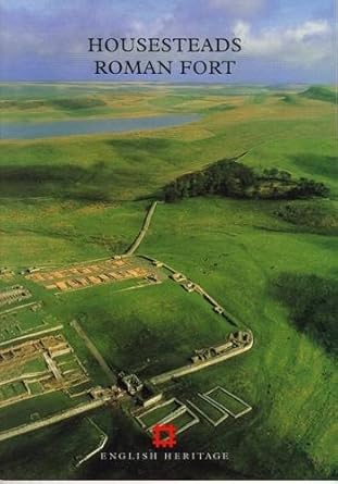
In
Housesteads you can see the foundations of the four major gates. Inside the
fort you can see the foundations of several buildings: the commandant’s house
(praetorium), the military headquarters (principium), the hospital
(valetudinarium), two granaries (horrea), two barracks, and (in the south-west
corner) the latrines.
South of
the fort there was a small village (vicus) with small houses (canabae). You can
still see the foundations of six houses below the southern gate, but in Roman
times there were more than six houses here. The civilian population provided
goods and services which the soldiers could not produce or get hold of by
themselves.
This ancient
site is the subject of an excellent booklet written by J. G. Crow and published
by English Heritage. The booklet is divided into four parts. The first part
presents a tour of the fort, including the local museum. The second part gives
information about the surrounding area, including the local village. The third
part gives information about northern Britain Hadrian’s Wall . The last part presents the history of the fort.
The text is
illustrated by a large number of photos, drawings and maps. Unfortunately, all
illustrations (except the pictures on the front cover and the back cover) are in
black-and-white. Fortunately, all illustrations are helpful and instructive.
The photos
show the current situation. They show what is visible today. The drawings are
modern reconstructions. They show what a particular building (probably) looked
like when it was new. A case in point is the colour drawing printed on the back
cover which shows the interior courtyard of the commandant’s house. The maps
give us orientation: there is a map of the fort and the surrounding area on pp.
30-31; there is a map of the fort itself on pp. 26-27. Other maps show the
layout of particular buildings: we have the headquarters on page 20, and the
hospital on page 22.
The first
part of the booklet – “A Tour of the Fort” – is divided into several short
sections, including the following:
* The south
gate
* The east
gate
* The north
gate
* The west
gate
* The hospital
* The headquarters
The local
museum is located in a small modern building south west of the fort. Here you
can see some of the objects found inside the fort and in the surrounding area.
My favourite is a small relief of three hooded deities (Genii Cucullati) found in a shrine in the local village and datable to around AD 230. They wear the hooded capes (byrrus Britannicus), which were famous as exports fromBritain
My favourite is a small relief of three hooded deities (Genii Cucullati) found in a shrine in the local village and datable to around AD 230. They wear the hooded capes (byrrus Britannicus), which were famous as exports from
Housesteads
Roman Fort is an important and interesting historical monument. It is worth a
visit. J. G. Crow has written an excellent guidebook about this site. Read it
before you go there. It will help you understand and appreciate what you see.
Bring it with you when you go there. The maps will help you navigate the fort
and the surrounding area.
PS. Be sure
to set aside some time to take a walk along the wall towards the east and/or the
west to get a feel for the landscape and the local conditions in this northern
corner of the Roman
Empire .
* * *
J. G. Crow,
Housesteads
Roman Fort,
English
Heritage, London
Reprinted
1992, 1995, and 1998, 52 pages
* * *
A new
guidebook for Housesteads Roman Fort, also written by J. G. Crow,
was published by English
Heritage in 2012. Here is the cover:
* * *
No comments:
Post a Comment